Saturday, August 8, 2009

St. Mary's Glacier Hike/Ski #2

See PHOTOS from our ski adventure HERE
See Erich's photos from our hike HERE


Yes, Hike and Ski! Yes, again! Yes in August!

We got our turns in for August today at St. Mary's Glacier (we skied here in July as well: July Blog Post). 11 consecutive months of skiing now.


St. Mary's Glacier stays around all summer and is only about an hour drive from Denver. We found out that it's not really a Glacier, because Glaciers move. This is just an area of snow in a valley that happens to stick around all year. So it's a "Glacier", not a Glacier.


This time Erich (Melissa's brother), Eric (my roommate from Breck) and Steph (Eric's fiance) all joined us for our hike/ski. Once you get to the trail head, there is a short 3/4 mile hike up to the lake. On the far side of the lake, the bottom edge of the Glacier can be seen stretching up the hillside. We made our way around the lake and started up the snow towards the top.


The weather was beautiful with blue skies (again). It didn't take us all long to make it to the top of the Glacier where we threw off our packs and clicked on our skis and boards. There was a little less snow than in July, bit we started at almost the same spot. The glacier was just a little narrower up top. The snow was still very variable with mogul like conditions to negotiate. We all enjoyed our turns in the dirty snow that was soft in areas and crusty in others. We finished with about 600 vertical feet under our belts for the month of August.


As we headed down the trail back to the car, with our skis strapped to our packs, we got quite a few inquisitive looks and comments from tourists taking a short day hike to the lake with their kids and dogs. We finished up the morning with a great lunch and a few pints at Tommyknocker Brewery in Idaho Springs.

Not sure where September will bring us for some turns, we'll have to see what mother nature brings between now and then.

Colorado Rules!

See PHOTOS from our adventure HERE
See Erich's photos from our hike HERE

Tuesday, July 28, 2009

Four Pass Loop

WARNING:
This post may make you quit your job and move to Colorado
(if you have not already)!!


For my birthday last week, Melissa and I headed out towards Aspen to hike the Four Pass Loop around the Maroon Bells. Here is a recap of our four day adventure along with photos and a compilation video. Enjoy!

Trip Statistics:
Days on trail: 4
Nights camped: 3
Miles hiked: 27
Passes crossed: 4
Valleys hiked through: 8
Start Elevation: 9,580 ft.
Highest elevation: 12,500 ft. (West Maroon Pass and Buckskin Pass)
largest elevation gain: approx. 2,420 ft. (Camp Two to Trial Rider Pass)
Largest elevation loss: approx. 2,920 ft. (Buckskin Pass to Trail Head)
Blisters: zero!
Approximate Route: Google Maps Pedometer

On Wednesday after work we started the three and a half hour drive to Carbondale, CO where my stepsister, Karen, and her husband Eric live. On the way we stopped in Edwards at the Gore Range Brewery for some dinner and a pint. We're always trying to add to our Colorado Brewery list! We got to Carbondale late in the evening and enjoyed a short chat with Karen and Eric before heading to bed. We woke early in the morning and headed up to Maroon Lake to hit the trail head.


Our backpacking trip around the Maroon Bells was amazing! From the awesome panorama views through the valleys filled with wildflowers, to the steep climbs up and over four passes. We only hiked about four hours each day and were able to relax at camp for a few hours each afternoon exploring the area and preparing dinner. We woke to the sunrise each morning and packed up camp to conquer the next pass. There were many other people doing the loop at about the same time we were, some the opposite direction. We would meet up with some of them at the passes and see them in the same areas for camps in the evenings. Camp One and Two were very peaceful, Camp Three, at Snowmass Lake had quite a few more people around us, but the views made us forget about that.


The weather for our trip was the best we could have hoped for. Blue sky days for day one through three. As we headed into the tent on night three at Snowmass Lake, it began to rain and poured off and on during the night. Fortunately it had stopped when we woke up and we were able to pack up camp without precipitation. The sun was in and out as we headed up to Buckskin Pass and as we rolled over the top, the clouds moved in quick and it began to rain and hail. The rest of the hike back down to the trail head was off and on rain, but it didn't bother us too much since we were headed for the car and not another camp.


After throwing our gear back into the car, we drove into Aspen to enjoy a juicy burger with fries. Boy did that taste good! We hit the road again, Denver bound. Little did we know that the anticipated four hour drive would soon turn into an eight hour trip. Unfortunately for us, ready for a shower and a comfortable bed after four days on the trail, a semi tanker truck had rolled over on I-70, shutting it down Eastbound for hours. We ended up taking an 80+ mile detour North through State Bridge and Kremmling and back down to Silverthorne to get back onto I-70. We ended up back at home around 1 a.m., dirty, tired and not wanting to head into work on Monday morning.

Surprisingly neither of us were too tired or sore on Monday. No blisters, no cuts, a few bug bites and a little sunburn were about all we had to show for our trek around the Maroon Bells. Oh yeah, and also about 400+ photos and some video!

I've cut down the photos to 241 for you viewing pleasure HERE. I think the photos tell a better story than I do, so have a look when you have a few minutes.

I also took 360 degree video at the top of each pass along with a few other clips here and there. You can view the compilation video HERE. It's about 6.5 minutes.


DAY 1
Start Elevation: 9,580 ft.
Left trail head: 9:15 a.m.
Miles to Camp One: approx. 5.75
Moving time to Camp One: 4 hrs. 7 min.
Camp One Elevation: approx. 11,367 ft.
Passes crossed: None

DAY 2
Start Elevation: approx. 11,367 ft.
Left trail head:
9:04 a.m.
Miles to Camp Two:
approx. 6.5
Moving time to Camp Two:
4 hrs. 26 min.
Camp Two Elevation:
approx. 10,000 ft.
Passes crossed:
Two - West Maroon Pass 12,500 ft. & Frigid Air Pass 12,415 ft.

DAY 3
Start Elevation: approx. 10,250 ft.
Left trail head: 9:17 a.m.
Miles to Camp Three: approx. 6.25
Moving time to Camp Three: 4 hrs. 40 min.
Camp Three Elevation: 10,990 ft.
Passes crossed: One - Trail Rider Pass 12,420 ft.

DAY 4
Start Elevation: 10,990 ft.
Left trail head: 9:50 a.m.
Miles to trail head: approx. 8.5
Moving time to trail head: 4 hrs. 21 min.
Trail head Elevation: 9,580 ft.
Passes crossed: One - Buckskin Pass 12,500 ft.

Approximate overall elevation map:

Monday, July 20, 2009

St. Mary's Glacier Hike/Ski


See PHOTOS from our adventure HERE
See a sort VIDEO from our adventure HERE or at end of post.

Yes, Hike and Ski! We got our turns in for July this past Saturday at St. Mary's Glacier. 10 consecutive months of skiing now, hoping to hit 20 at some point.

St. Mary's Glacier stays around all summer and is only about an hour drive from Denver. Once you get to the trail head, there is a short 3/4 mile hike up to the lake. On the far side of the lake, the bottom edge of the Glacier can be seen stretching up the hillside. We made our way around the lake and started up the snow towards the top. There were a few other people hiking up and one guy on skis just finished his descent as we climbed.


The weather was beautiful with blue skies and a bit of a breeze to keep you cool as you hiked. It did not take us long to make it to the top of the Glacier where we threw off our packs and hiked up a bit more over the ridge line to see what was on the other side. You could see the top of James Peak (13,294 ft.) in the distance.


After a quick snack, we strapped on our skis and headed down negotiating the variable and wavy snow conditions. As the snow melts during the summer, wave like patterns are created across the surface of the snow. Tricky to negotiate, especially on teles. But we enjoyed our turns in the dirty snow that was soft in areas and crusty in others. Towards the bottom we saw a large group of snowboarders headed up with rails, shovels and coolers in tow. It would be a great spot to hang out for the weekend and build some jumps. We finished with almost 900 vertical feet under our belts for the month of July.


As we headed down the trail back to the car, with our skis strapped to our packs, we got quite a few inquisitive looks and comments from tourists taking a short day hike to the lake with their kids and dogs.

"Did you go skiing!?", one man asked, "You guys are hardcore!", another women stated. Guess we are hardcore, but we just think of it as a nice walk in the mountains with the opportunity to enjoy where we live.

We are thinking we may head up there again for our August turns. It should still have some pretty good snow pack then as well.

Colorado Rocks!


See PHOTOS from our adventure HERE
See a sort VIDEO from our adventure HERE or below.

Monday, June 29, 2009

Mt. of the Holy Cross


See photos from the trip HERE
See a video clip of the Holy Cross valley HERE
See a panoramic video clip from the summit HERE

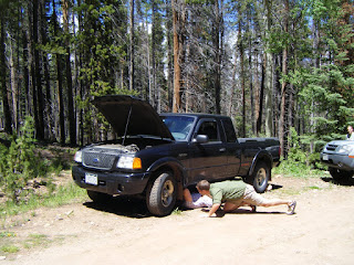
Well, it was quite the interesting weekend to say the least. On Saturday morning we headed out towards Vail to do some hiking, fishing and camping in the Holy Cross Wilderness. As I drove up Tigiwon Road, the eight mile access road to the campground I had a wee problem with my truck. White smoke stated to appear from the undercarriage and I lost all power on the gas. Upon stopping around a corner, I exited to find pretty much all the transmission fluid leaking out onto the road. Ends up I blew the transmission. The truck was towed to the nearest mechanic to sit for the weekend. Fortunately our friends Jaimee and Wes were on their way to join us, so we threw all our gear into their truck and continued on. We were a bit short on room in the Xtera, but it all worked out and we made it to the campground.


After setting up camp we hiked a bit up one of the nearby trails to Notch Creek and did some fly fishing near a beaver pond. The little brookies were biting and we caught a few before we headed back to camp for dinner.


Bright and early on Sunday, 4:00 a.m., Melissa and I woke to hit the trail and hike to the top of Mt. of the Holy Cross. As the sun rose, we arrived at the top of Half Moon pass, about 1,000 ft. vert from camp and at treeline. The trail then heads back down to the valley floor another 1,000 ft. We were not looking forward to tackling that on the way back. After traversing across the side of Notch Mtn. we got our first impressive look at Mt. of the Holy Cross. Quite a site and very imposing to see what the rest of the hike would look like along the north ridge. See a video clip of the Holy Cross valley HERE


After descending to the valley floor and crossing a raging creek, we again began to ascend back towards treeline and the corniced ridge to the summit. We hit some rough bouldered areas along with snow fields and the long cornice, but most of the trail was dry and clear of snow. The views surrounding us were amazing. The snow cornice provided relief from picking through the rocky ridge. After the snow ended we had a sharp ascent to the peak through a rock filled face.


Finally at the peak, mostly covered by snow, we rested and enjoyed the views for about 40 min. This was 14er number 10 for me (plus two double ascents) and nine for Melissa (out of 54 in Colorado). We shared the summit with four other humans and two canines. One of the girls at the top was only 11 and planned to hike all the 14ers by age 17. We wish her good luck and happy climbing! See a panoramic video clip from the summit HERE


After a snack and some hydration we headed down. It was going to be a long trip back. Sometimes you think the way down will be easier than the way up, but after hiking over five miles with 5,000 ft of vert, every step down takes as much effort as the steps up. We saw quite a few Marmots in the boulder field near treeline. As we got closer the the valley below, we remembered the 1,000 ft. of vert we were approaching that was between us and our campsite. The trail that switchbacks multiple times on the way back up to Half Moon pass ends up being one of the hardest parts of the route. We are used to heading all downhill back to the trail head. We pushed through it and returned to camp with another 14er in the bag, 11.5 miles of hiking with almost 6,000 ft of vert in about 9 hours (and one blown transmission).

What a great weekend, for the most part!

Which one will be next on the 14er checklist? Stay tuned to CO Adventure to see.


See photos from the trip HERE
See a video clip of the Holy Cross valley HERE
See a panoramic video clip from the summit HERE

Monday, June 22, 2009

Arrowhead Golf Day


See photos HERE

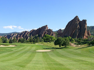
Melissa, Rich and I went golfing at Arrowhead Golf Club, south of Denver, for a Fathers Day Celebration on Friday. The views were amazing! So much that it greatly distracted us from our games. We won't mention the final scores.

We saw deer, fox, gold eagles and bull frogs on and around the course. Missed out on the bear and mountain lion that the staff said were around as well. It was a beautiful blue sky day and we all had a great time.


See photos HERE
(Rich contributed some of his photos to this album)